Data versus the ‘Discardscape’

With the ever-pervasive visualisation of data and real-time tracking potential of urban informatics, the ability to be completely immersed in the screen becomes increasingly distracting if not necessarily helpful with regard our concerns about the contemporary built environment. Obviously in silico is not the same as in concreto. So let us look toward something very real – Detroit. What emerges as particularly important about Detroit as we move through the clutter of ruin porn imagery and much-publicised crime and deprivation statistics is that it is at once both specific (happening right now, as one of the leading-edges in advanced capitalist conditions) but also increasingly everywhere (representative of many other places in the US and Europe). As Jerry Herron accurately defined the situation, “Detroit may be emptied out, then, but it is hardly over, nor will it be anytime soon, precisely because of the questions that this city/not raises.”[1] As tempting as it may be to consider such a place to be relegated to the past if not entirely redundant, many of us still live in these situations so we need to address this. Indeed, it is worth reiterating Rebecca Solnit’s point here regarding the very practical reason Detroit will evolve through sheer necessity since it is “where change is most urgent and therefore most viable.”[2] If we start to pursue this idea further then perhaps the most helpful way of considering Detroit is as a series of situations borne of relationships rather than permanent fixtures. This of course holds for other urban contexts but seems especially pertinent to this one. As such, Rice’s recent description may be brought to bear, “To call Detroit a network is to call it an account, not a fixed representation of space. It is to simultaneously call it the physical locale we have always known to be Detroit, but it is also to call this space something else.”[3] This points toward the durative nature of meaning making, which affords our perception of places to evolve through further encounters, experiences and events. The networked or, perhaps more usefully termed, relational aspect of a physical context is crucial to our understanding and interpretation of such situations. Whether evident as a coherent city form or fragmented ‘discardscape’ such as Detroit, the web of explicit and latent connections that constitutes the urban environment, supports Amin & Thrift’s notion of an expanded politics of representation.[4]

Carol Anne, Poltergeist, 1982

Carol Anne, Poltergeist, 1982

The failings of capitalism, and, in particular, its withdrawal, are omnipresent across Detroit. Despite this, the hope, perseverance and creative commitment of groups of its citizens remain defiant in developing counter strategies to affect positive change. Data Driven Detroit is one such initiative that provides a nonprofit, independent data centre to promote positive community change. As part of their remit the organization has produced the D3 Toolbox, envisioned to support communities with the data necessary for them to take action in their neighbourhoods.[5] The relatively nascent character of such enabling instruments means it is perhaps too early to ascertain the full uptake and impact of them, but their availability is undoubtedly a move in the right direction. Another salient example is the Ponyride project, which explores how the foreclosure crisis may be used to “provide cheap space for socially-conscious artists and entrepreneurs to work and share knowledge, resources and networks.”[6] In a similar vein, other organizations such as Detroit SOUP and Kiva Detroit are enabling citizens to actively contribute toward the distribution of grant funding and microloans respectively to facilitate communities to improve their neighbourhoods and district.[7] However, whilst all of these valuable incentives are using online presence to evolve and disseminate their structure and content, it may also be possible to develop a more explicit, adaptive and integrated way of coupling user-gathered data with urban transformation.

Neighbourhood Parcel Tool, Data Driven Detroit, 2012

Neighbourhood Parcel Tool, Data Driven Detroit, 2012

This aim may be the next logical step for community platforms such as Outside.in, which uses HTML and database software to compose structured city spaces where citizens define places, stories, and events that shape a community.[8] This type of ‘hyperlocal’ content is considerably more situated in its character, offering appropriate filtering and collation of data to key issues and concerns that affect a neighbourhood. Indeed, the elements identified above, i.e. resources, data, networks and intelligence, are integral to the manner in which interfaces such as this produce data-driven mediations of personal interactions with places. It is these personal engagements with physical space that reflect the contingent, itinerant and embedded qualities of our relationship with the immediate context. Of course, this is not the only platform to provide highly localized content with other aggregated blogs and mapping websites available with which the experiences and concerns of citizens and their interactions are cumulative and integrative in nature.[9] It is therefore proposed that it may be across platforms such as these that the elusive preparatory framework of an “alternative to neo-traditional models of planning and urban design and their naïve revisionist strategies for the recuperation of the pre-industrial city,” may be found.[10] Through the accretion and evolution of projects and initiatives such as these it may be possible for Detroit to become the ‘syncopated urban landscape’ it is capable of becoming.[11]

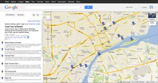
Toxic Tour of Detroit, Detroiters Working for Environmental Justice, 2011

Toxic Tour of Detroit, Detroiters Working for Environmental Justice, 2011


[1] Herron, J. (2010) ‘Borderland/Borderama/Detroit,’ in: Wilkins, G. [ed.] Distributed Urbanism: Cities after Google Earth. Oxon: Routledge, pp. 63-86.

[2] Solnit, R. (2007) ‘Detroit Arcadia: Exploring the post-American landscape,’ Harper’s Magazine, July, pp. 65-73.

[3] Rice, J. (2012) Digital Detroit: Rhetoric and Space in the Age of the Network. Carbondale, IL: Southern Illinois University Press, p. 6.

[4] Amin, A. & Thrift, N. (2002) Cities: Reimagining the Urban. Cambridge: Polity.

[5] To explore the current tools provided see: <http://datadrivendetroit.org/data-mapping/toolbox/&gt; [Accessed 1 October 2012]

[6] More information available at: <http://ponyride.org/&gt; [Accessed 4 October 2012]

[7] For further details on both of these worthwhile projects see: <http://detroitsoup.com/&gt; and < http://www.kiva.org/detroit&gt; [Accessed 4 October 2012]

[8] The ability to connect citizens with one another and interlink news, events and places is enabled through the streaming of hyperlocal content, providing a digital counterpart to the physical neighbourhood: <http://outside.in/&gt; [Accessed 1 October 2012]

[9] Platforms such as Google Maps and Wayfaring are empowering citizens and groups to develop specific content around political and environmental concerns, for example the Toxic Tour of Detroit map produced by Detroiters Working for Environmental Justice in 2011. Available: <http://dwej.org/dwejonline/?page_id=531&gt; [Accessed 1 October 2012]

[10] Daskalakis, G., Waldheim, C. & Young, J. [eds] (2001) Stalking Detroit. Barcelona: Actar, p. 12.

[11] Pitera, D. (2010) Detroit: Syncopating an Urban Landscape. Available: <http://places.designobserver.com/ feature/detroit-syncopating-an-urban-landscape/14288/> [Accessed 4 October 2012]

Infrastructure + Interstice

Architecture has become increasingly marginalized and distanced from its role as an aid to humanity and society in the last twenty years by responding primarily to the demands of the market. It may therefore be useful to shift our attention to the public role of the architect by (re)defining ‘value’ in the built environment. If we are to assign ourselves to a redistribution of the design process that may build upon a platform of local needs via global networks, then the indeterminacy of interdependent economic, political and cultural systems should be embraced, rather than ignored, to enable suitably elastic design strategies to respond to the dynamic conditions of urban landscapes. The potential to develop an adaptive system to address the multi-scalar characteristics of cities may offer the urban, whether local, national or global, to emerge as a hybrid of topological and topographical relationships thereby providing a more comprehensive integration between digital networks and the physical urban landscape.

Toyota’s driving simulator (2007). Where virtual and physical collide.

The constant modelling (read: mapping) of existing systems does not necessarily make future predictions a certainty. Perhaps one of the main stumbling blocks here is the attention lavished on ‘form’ rather than ‘systems’ which has to date resulted in a preoccupation with objects rather than infrastructure. The role of infrastructure is often viewed as the primary area of investment for governing bodies in the development of cities around the globe. With the increasing urbanization of the physical landscape, infrastructural development is perhaps the key defining feature of this landscape with the attendant capacity to integrate, or negate, territories and stimulate social, economic and cultural activity.

Cactus mobile phone mast being installed.

The dissolution of space and the latent regulatory landscape, that define our urban environment, serve to demonstrate the polarization of architectural extremes and characterize the current condition in the production of architecture; the unregulated (pop up shop, temporary pavilion, favela, street food, illegal trading) and the hyper-regulated (transport interchange, school, data centre) . The transition from architecture as mediator of the ‘city’ to architecture as mediator of the ‘urban’ has already occurred. As the order of space, light and form has ceded from the production of architecture it is possible to describe a situation wherein the projects that successfully negotiate infrastructure and the urban condition can be seen to exemplify this shift. OMA’s entry into the competition for Parc de la Villette, Foreign Office Architect’s Yokohama Port Terminal and Zaha Hadid’s Phaeno Science Centre, function successfully within the supermodern image-sign-object schema but also transcend notions of the city by engaging with infrastructural urbanism. These building types and projects may come to represent the new dynamic of urbanism in the context of architectural production.

Yokohama Port Terminal. Foreign Office Architects (2002). Infrascraper.

Originally coined by the Japanese architect Fumihiko Maki in 1964, the term ‘megastructure’ was defined as a vast frame in which the many functions of a city could be incorporated [1]. Subsequently popularised by Reyner Banham through his book of the same name in 1976, the term has evolved to describe repetitive systems that enable a high degree of variation to occur, and recur, as a response to programmatic and contextual requirements. Perhaps, therefore, the transformation of the public realm is not one of erosion but of (re)distribution of its spatial and social properties. Rather than referencing the former exemplars of architectural history, this new domain may be found as being intrinsic to infrastructure IE we have moved from the piazza to the platform as a collective place. This appears to be borne out by the provision of programmes like meeting spaces, food courts and shopping arcades in train stations for people who may not even be using the transportation network. Considered in this way, the commodification of public space by privatized organizations may actually be seen to have reignited urban space rather than be the ‘Junkspace’ it is often perceived as.

Hauptbahnhof. Berlin.

Atelier Bow Wow’s Made in Tokyo alludes specifically to this condition, using a taxonomy of ‘un-designed’ hybrid buildings to reveal more about the nature of Tokyo as a city of flux, where no building is greater than fifty years old. In Tokyo, as with Los Angeles and Las Vegas before it, urbanists can locate a specific characteristic of city, which provides an amplified version of a generic condition, in this instance: temporality. The numerous examples of low-tech hybrids that combine infrastructure and public space are evidence of this transition from materially bound ‘city’ production to network bound ‘urbanism’. These buildings that negotiate their spatial limits in the pursuit of functionality do so in the manner of an intervention, their form is an explicit dialogue between programme and available spatial envelope.

Pet Architecture. Occupying the interstice.

The negative space that is the very product of our progressive society and its infrastructure finds itself as the only physical niche available for expression and this type of intervention can be seen to be reflective of and challenging to the orders of society and space. Reactionary, parasitic, mutable and networked are all characteristics of actions that inhabit the interstice and of the built manifestations of global brands and idioms that form our cities by consumption; the parallels are as evident as the paradox.

[1] Maki, Fumihiko, Investigations in Collective Form, A Special Publication Number 2, The School of Architecture (Washington University: St. Louis: June 1964)

Welcome to the Ageing Future

This is a video produced by former [Re_Map] student, Joe Haire. Joe was one of Building Design magazine’s Class of 2011.

In his words:

A video demonstrating automated design and model construction using Excel and Maya.

Buildable volumes are set out on an excel grid as ‘1’ and void as ‘0’. The first level being the area within the site boundary. Each subsequent level of volumes is a product of the one beneath it, defined through a cellular automation relationship. This process allows form and total volume to be controlled precisely for large numbers of units.

This information is then fed into maya. Each volume is evaluated to determine its position within the model, the condition of its neighbors, its surrounding density etc. These conditions define what type of programme is built in that volume based on a set of rules collected from the thesis research into care provision.

A bespoke model is then produced, to the specific care requirments of the demographic and within the specific constraints of the site, that adheres precisely to the programmatic relationships required by the modern care community.

From BD:

“This thesis explores solutions to our care deficiency, elderly mobility issues, community fragmentation and our attitudes towards the elderly,” says Joe Haire, whose project proposes a network of gigantic cellular clusters to house Huddersfield’s 22,000 pensioners.

A “utopian solution to the later stages of life,” the project comes out of the “Re_Map” design-by-research unit, taught by Richard Brook, which explores urban socio-political conditions using data and computational analysis.

In order to generate the clustered form – which is strongly reminiscent of Constant’s New Babylon – Haire developed a code that would distribute form, programme and services to the specification of the required demographic of the community and within the constraints of the site.

Haire’s vertical cluster for 6,000 pensioners in Huddersfield “takes 10 seconds to calculate and design”.

Haire’s vertical cluster for 6,000 pensioners in Huddersfield “takes 10 seconds to calculate and design”.

Using Excel, each level of the model is defined as a product of the one beneath through cellular automation, while a code written in Maya then evaluates each volume to determine its programmatic typology within the overall scheme. “Each community of 6,000 people takes roughly 10 seconds to calculate and design,” says Haire.

The judges were as frightened as they were compelled.

“There was enough megalomania in this project to sustain a whole architectural career,” remarked Charlotte Skene Catling, while Catherine Ince saw it as a critical warning.

“His dark, provocative take on the pressing issue of aging populations offers an ominous view of what might happen if we don’t address our attitude to the elderly,” she said.

“It is boldly tackling urgent contemporary problems head on, from our aging population, to prefabrication and what to do with ailing northern towns,” agreed Dominic Cullinan.

London heliport

Part of our research recently has involved the story of the development of inter-city helicopter travel in the UK during the 1950s. As such we have been trawling the collection of the National Archives at Kew. One informative document we have come across concerns the proposed siting of heliports (helicopter stations) in the capital, 1961. (REF:DSIR 23/34668)

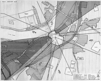
Amongst the proposed sites are two for the area around Nine Elms Lane, precisely where yesterday’s tragic collision occurred. There are many reasons for the non-arrival of mass inter-city helicopter transport, but safety was one of the big issues, particularly around the heights of structures in proximity to landing sites, as the splays superimposed on the plan below suggest.

One of nine proposed sites in the report.

One of nine proposed sites in the report.

eltono – navigator|commentator

[Re_Map] for those not in the know (it’s something we are occasionally specific about) stems from our combined interest in representation and mapping in architecture and the allied arts. In Urban Maps we write about Objects and Marks in the urban landscape; referring to art, both sanctioned and illegal. We are of the opinion that certain acts and events made by artists and/or graffiti writers, because of their temporal nature and the sites in which they occur, can provide a commentary on the city in ways in which the built edifices of architecture cannot. For example – the revelation and exposition of interstitial and residual spaces, the discourse between infrastructures and the city and ideas concerning entropy, space, motif, navigation and other experiential narratives. There are some artists that tread the ground beyond graffiti, but are influenced by its traditions and practice as well as being informed by other art that has inhabited the urban environment. Perhaps the most celebrated of these is Invader, not least of all due to his recent exposure in Banksy’s film. Invader’s work with maps is well known and he publishes these artefacts for collectors and fans to buy. Less discussed in terms of his works using mapping as part of his process is Eltono. Eltono has slowly and naturally migrated away from conventional graffiti to develop his own form of negotiation with the city over the last fifteen years, beginning with the mutation of his name into a motif and subsequently shifting from the use of aerosols to brushes and masking tape. Eltono’s ‘tuning fork’ device is intriguing in its negotiation with space and material as each time he applies it to a surface it is slightly mutated in colour and form in an intuitive dialogue with site. This act in itself is architectural, insofar as it carries contextual, spatial, formal and material meaning and can be interpreted using the same. It is in mapping though that Eltono has begun to develop new dialogues with the city, most markedly during a short residency in Vitoria at the Artium Museum.

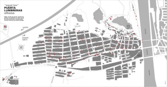
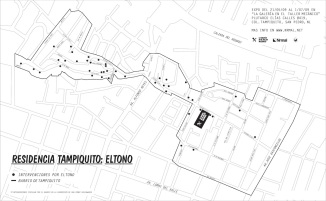
Eltono’s early mapping exercises were most simply about making a record of his works in sanctioned environments and to accompany exhibitions or residencies. The first two published maps were from projects in Spain and Mexico, at Puerta Lumbreras and Tampiquito respectively. These maps were produced as a record of his interventions and in some senses challenge the graffiti norm which is to photograph, but not necessarily to geo-locate, works.

Map of Eltono's intervention paintings in Puerto Lumbreras

Map of Eltono’s intervention paintings in Puerto Lumbreras. Copyright Eltono.

Map of Eltono's intervention paintings in Tampiquito

Map of Eltono’s intervention paintings in Tampiquito. Copyright Eltono.

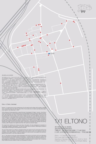
At Caochangdi in China, the act of mapping was inherent in the process of the project from its inception, in Eltono’s words:

At the entrance of Caochangdi there is a sign that reads “Caochangdi Art Village”. However, when Eltono came for the first time, he was surprised to find an almost tangible frontier dividing the village and the galleries. After spending a few days in Caochangdi it became clear to him that the people who come to visit the galleries often miss the village, and very few villagers go and visit the art galleries. During his one month residency in Caochangdi, Eltono decided to use his paintings to create a link between these two worlds. To begin, he mapped out the village including all of the tiny streets and alleyways, noting down all the doors he found interesting or inspiring. Entering into conversation with the villagers he explained the goal of his project and asked permission to paint their doors – this served as the first link between the artist and the village. Over the next several weeks, he spent time connecting with residents and painting, creating a path throughout the neighborhood filled with mysterious abstract images.

The subsequent exhibition entitled 1:1 addressed ideas of translation and scale; also present in Land Art and also discussed in terms of its relationships with architectural discourse – we recall Robert Smithson’s Non-Sites in this regard. The map that was produced was not simply a product of the act of mapping, but also an invitation to participation, another recurrent theme in Eltono’s work. In this way the map began to become a part of the work rather than simply a record of it. Invader’s maps have similar operative and performative qualities embedded in their production too.

Map of Eltono's intervention paintings in Caochangdi

Map of Eltono’s intervention paintings in Caochangdi. Copyright Eltono.

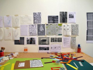
The residency and installation in Vitoria was called Deambular, from the Latin deambulāre; to wander. The entire project has been well recorded and written about by both Eltono and Javier Abarca. Here Eltono has taken his mapping activities into new territory and produced a static record of temporal events. During the eleven days of the residency Eltono placed paper versions of his abstract motif in locations typical of his usual sites, doorways, boarded up windows and gaps. These were installed using drawing pins and each day he would visit the site of the installation and record the changes to the motif where pieces or pins had been removed. As well as making this record he also used small, coloured stickers to record his own movements through the city streets. These daily traverses were colour coded and ultimately transposed to a map and scaled to the wall of the gallery to produce a series of abstract forms. The method for translation was much like that of a geographer or transport analyst in that the more frequently used paths were represented using a wider line. This classic mode of translation calls to mind the now seminal map produced by Paul-Henry Chombart de Lauwe showing all the movements made in the space of one year by a student living in the 16th Arrondissement of Paris and referenced by Guy Debord. Here though, Eltono moves past the Situationist’s production and into realms of mapping that are hard to locate, in terms of their genesis, other than having slowly emerged from ‘post-graffiti’ [1] practice. Debord would probably have ejected a collaborator from the Situationists for being too definitive or productive had they made work of this type, but it is precisely this act of mapping and representation that is of relevance to urbanism.

Eltono's workspace left as part of the installation. Copyright Eltono.

Eltono’s workspace left as part of the installation. Copyright Eltono.

The daily maps as recorded on photocopies. Copyright Eltono.

The daily maps as recorded on photocopies. Copyright Eltono.

The daily maps transposed onto the gallery walls. Copyright Eltono.

The daily maps transposed onto the gallery walls. Copyright Eltono.

The complexities of the contemporary city witness all sorts of attempts by individuals and organisations to try and make sense, rationalise or navigate and in some way Deambular provides a commentary on these forces, events and conditions. It is an attempt to order an experience of place as well as an ambient translation of motion. The routes are informed by pivotal locations of preselected sites for intervention, but also influenced by need – for food, for drink and for materials. In this way they are a negotiation between intent and necessity, possibly reflective of each of our engagements with the urban environment on a daily basis; one which is rarely made visible or manifest. Eltono, quite literally, frames the everyday and follows the Parisian tradition of Debord, de Certeau, Lefebvre – by design or by accident? There are other art forms that involve mapping, but the contemporary movement of mapping in art is quite different in its forms and discourses from those presented to us by Eltono and Invader. There is also a recent history of motion and the city – the work of Francis Alÿs with ice and with guns sping to mind – but this too is different from the evolution of methods attributable to certain street artists. The temporality of the marks made in the process and the personal maps made of the motion provide a loose and momentary ‘fix’ of one experience of place but can be seen to characterise the type of experience encountered by everyone. This ordering of the city is similar to the unpublished cognitive maps that we each construct in going about our business and the slight, and accepted, imprecisions in the placing of dots and in the translation of the maps are emblematic of the minor deviations from our own standardised norms. To understand this particular work as a commentary on the production of space is also to understand our own experience.

[1] The term post-graffiti is used here to mean very specifically art that draws on the graffiti tradition and methods but has moved beyond the simple act of applying a repeat moniker and has entered into a more sophisticated engagement with place. It was first coined by Paul Tschinkel when ART/new york issued the documentary video Graffiti/Post Graffiti (1984). It has subsequently been used elsewhere but can be viewed as a slightly pretentious phrase for ‘street art’. In this instance it is intended to form a distinction between art that adopts graffiti traditions and art that moves beyond them.

the end of architecture?

Through its commoditization and acquiescence to the demands of the market, architecture has increasingly become marginalized, if not entirely circumvented, from its role as an aid to humanity and society. If, as both Fredric Jameson (1994) and, more recently, Mark Fisher (2009) have suggested, “it’s easier to imagine the end of the world than the end of capitalism”[1][2], then we need to fundamentally rethink the means through which we may achieve effective, adaptive and contingent political mobilization to positively alter the urban landscape. The potentially transformative power of data, ceded to the masses, may provide the necessary impetus toward a substantial restructuring of the city, but only if its systems are capable of negotiating the attendant issues of governance, antitrust policy and security measures. It is these concerns that provided the foundation for the research paper, ‘The End of Architecture? Networked Communities, Urban Transformation and Post-Capitalist Landscapes’ presented by the authors at the recent Spaces and Flows: Third International Conference on Urban and ExtraUrban Studies held at Wayne State University, Detroit, 11-12 October 2012. The paper examined the notion that if we are to consider the future transformation of our cities, then the communities within them must be given priority as stakeholders. If we really are living in the end times of Žižek [3], we need to energetically and openly engage with the provision of a framework to evolve ‘intelligent terrain’ that is participatory and enabling. This idea was further unpacked in the context of Detroit, interrogating the data-driven toolkit currently available there in relation to its governance, communities and the (re)configuration of space [4].

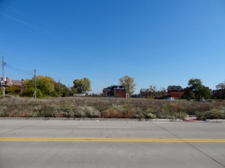
the discarded city, Detroit, 9 October 2012. [photo by author]

[1]. Jameson, F. (1994) The Seeds of Time. New York, NY: Columbia University Press.

[2]. Fisher, M. (2009) Capitalist Realism: Is There No Alternative?, Ropley: Zero Books.

[3]. Žižek, S. (2011) Living in the End Times, Revised Edition, London: Verso.

[4]. http://datadrivendetroit.org/

polarities

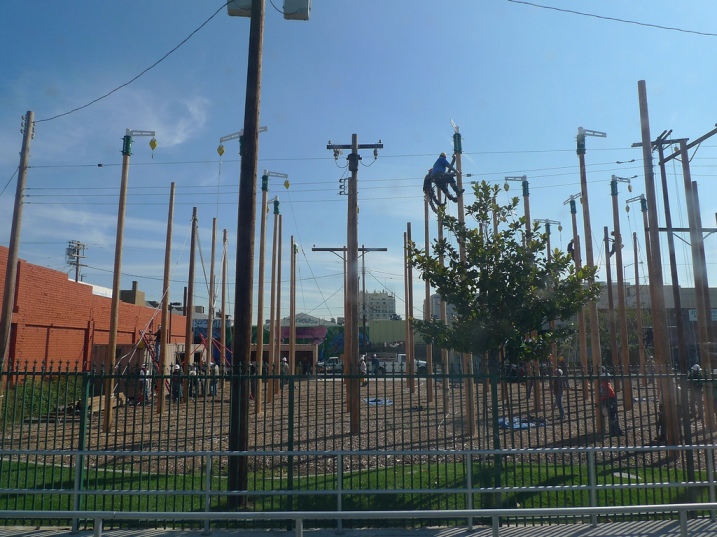
As visitors here will be aware, here at [Re_Map] we research and explore instruments of spatial control. We are interested in the discrepancy between the apparently infinite, seamless topology of digital space and networks, and their contrast with the typically fragmented, incoherent topography of contemporary urban landscapes. The question of what constitutes territorial, community, networked and residual space is paramount to our research. Indeed, our daily interactions with one another quickly make us aware that network structures have rapidly evolved to form the organisational model of socio-cultural exchange and technological development in the digital age.[i] Therefore we were pleased to recognise that even the smooth space of the Internet needs a little help sometimes. The photograph below is by Alissa Walker, and illustrates a telephone pole farm in Los Angeles, used for repair personnel to practise their skills in a hyper-regulated copse before entering the unregulated urban jungle.


[i] For an overview see: Guido Caldarelli, G. (2007) Scale-Free Networks: Complex Webs in Nature and Technology. Oxford: Oxford University Press.

future forming (and other strategies)

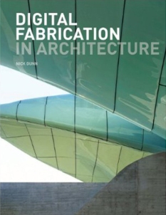
Here at [Re_Map], we share the view that we have entered a post-digital age in which how and why we design has become as significant as what we design. As part of our ongoing research and critique into modes of representation and production, a new book by Nick Dunn has just been published, ‘Digital Fabrication in Architecture’ (Laurence King). The publication features work from leading-edge practices and researchers from around the globe as well as numerous [Re_Map] alumni.

Architecture is fundamentally concerned with two core activities: designing and making. Of course, these are not mutually exclusive and often inform one another in a continuous dialogue as projects progress from concepts, through design development to final form – typically the realization of a building. The ability to effectively communicate creative ideas remains a central aspect of the discipline. With the development of numerous Computer-Aided Design (CAD) and other software packages, the variety of design processes available to architects, which may influence the fabrication of architecture and its components, is greater than ever. Of specific interest in this field is the recent capability of completely digital workflows or the ability to integrate analogue and digital techniques and processes to produce physical objects, whether three-dimensional concept diagrams, scale models or full-size prototypes.

As such, there has been considerable emphasis on the notion of ‘digital craft’ which, rather than the relationship between human and the machine creating distance from the design and making process, actually reinforces the level of engagement between the two. Therefore, whilst some of the contemporary tools we may now use differ vastly from those used in previous times, the idea of craftsmanship still prevails in the sense of a designer who is involved in a cyclical process between the generation of an idea, its representation (whether through drawing and/or modelling), and its fabrication.

This book seeks to bridge various gaps in understanding through three major themes:
1. Generation – how do we produce and develop design data?
2. Integration – how do we than use this design data, since it is often also the construction data, in a meaningful and creative manner?
3. Strategies – what are the overarching approaches connecting geometry and material, design and fabrication?

DFiA

‘This welcome publication is inspiring, informative, lusciously illustrated and methodically structured. As digital fabrication technologies seep evermore into the daily routines of design practice, it should provoke more designers to become familiar with these tools, and to exploit their potential as makers.’

– Bob Sheil, RIBA, Senior Lecturer and Director of Technology and Computing, The Bartlett School of Architecture, UCL

‘Nick Dunn has perfectly situated this book at a point where advanced thinking in architecture meets emerging, cutting edge technologies. Digital Fabrication in Architecture is as inspiring as it is informative.’

Thom Faulders, Architect, Faulders Studio, and Professor, Department of Architecture, CCA

Abstract Urban Topographies – Data Mapping # 2

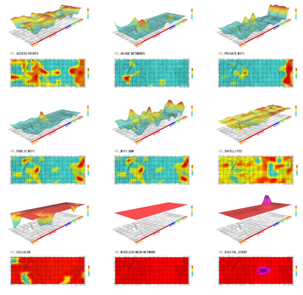
Composite geo-spatial datascapes, in which invisible characteristics of the urban/rural landscape are attached to physical topographical information, have become increasingly prevalent in our attempts to understand the flows and processes that accord further definition of our environment and, indeed, its experiential qualities. This project, developed by Robin Burek, utilised Ordnance Survey grids and the points therein to take a series of data readings in order to determine Wifi signals, 3G and cellular signal strength. By taking GIS readings at each survey point this data was then mapped as a new thermo-terrain within the defined field and superimposed upon one another to create an overall topography of network connectivity. This was in the context of Huddersfield promoting itself as a home for new digital industries. The results were used to inform site selection and programme definition for a masterplan based on sustainable transport infrastructure and integrated urban development.
Image


Cellular Urbanism – Data Mapping # 1

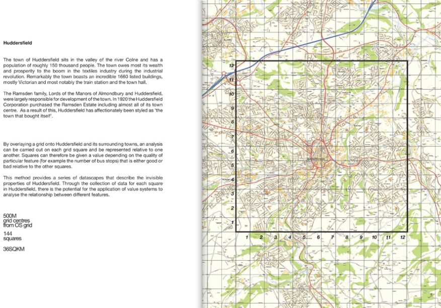
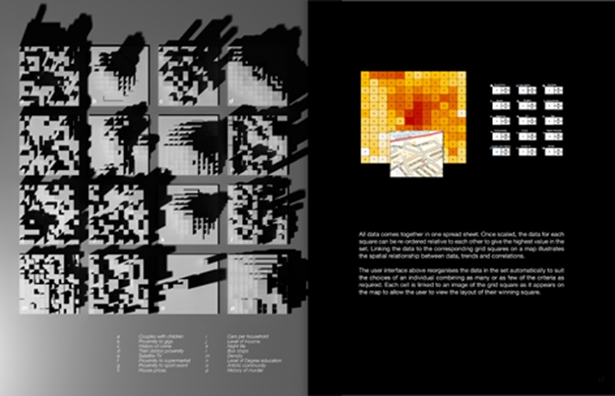
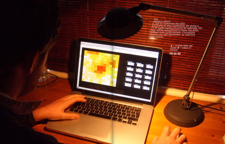
The use of maps in relation to cities and our experience of them is both a familiar one and historically extensive. Our engagement with an unknown city is nearly always translated through the map whether illustrating streets, tourist destinations or transportation systems. Indeed, urban experience in an unfamiliar context is typically an exchange between cartographic spaces and the materials of the built environment. Considered in this manner it is evident that urban and cartographic spaces are entwined and continue to exist in a mutual relationship with each other, surviving temporal shifts and developments. With the increasing growth of potential opportunities and creative practice for urban mapping it is important to remember that the critical discourse surrounding public space and notions of privacy and place must continue in order to parallel such developments and frame them in an intelligible manner. One of the most prevalent capacities of the information age is the accessibility and exchange of data, rendering the previously latent visible. This project, developed by Joe Haire, Felicity Hurling, Dicky Lewis and Dan Stock, created an interface for data collation, cellular automation and site designation.

  • By utilising the interface of postcode data and Ordnance Survey grid based sub-divisions it is possible to design live applications that offer a multitude of possibilities not simply confined to architecture or urban design.Image
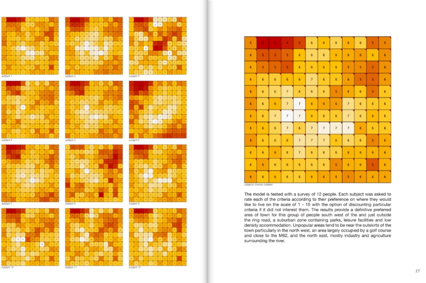
  • In this particular manifestation live data from a number of sources pertaining to lifestyle choices was streamed to a cellular automata model. Image
  • This included crime rates, house prices, leisure facilities and such and their respective incidence in each cell. By using a sliding scale against the assigned 15 parameters prospective householders or developers were offered possibilities as to the best area to live or to start their business.Image
  • The possible application of this software is effectively limitless in terms of the scale at which it is applied, the number of parametric inputs and the needs of any particular user as yet undetermined.Image